FEB. 3, 2002 SULTANDAGI (TURKEY) EARTHQUAKE
Report
by the Department of Earthquake Engineering, Kandilli Obs. and Earthquake
Res. Ins., Bogazici University.
Prof. Dr. M. Erdik, E.Uckan, K. Sesetyan, M.B. Demircioglu, U.Celep, Y.Biro
www.koeri.boun.edu.tr
UPDATED
ON MAR. 5, 2002
I.
General
II. Tectonics
III. Seismicity
IV.
Soil Conditions
V.
VI. Damage
VII. Performance Of Building Structures
An earthquake of magnitude Md 6.0 (Mw = 6.3) occurred on February 3, 2002 at 9:11 local time causing damage and casualties at the town of Afyon (population: 183,351) and its provinces (Sultandagi, Cay, Bolvadin, Cobanlar, Suhut, Aksehir). The macroseismic epicenter is located near the Sultandagi province and the earthquake is associated with the Sultandagi fault zone. Three major aftershocks with magnitudes between 5 and 6 followed the main event. One of those (Mw = 6.0, occurred at 11:26 local time) is also considered as another main shock. Total dead count is 43 with 260 injured. The peak horizontal accelerations recorded are around 0.1g.
The main tectonic features of
Central and Western Anatolian regions are illustrated in Figure
1. Extensive
investigations have showed that, numerous graben systems have been
forming in the E-W and WNW-ESE directions due to the N-S substantial
extension in the Western Anatolia (Ketin 1968; Dewey and Sengor 1979;
Jackson and Mc Kenzie, 1984). Gokova, Buyuk Menderes, Kucuk Menderes,
Gediz, Bakircay, Kutahya, Eskisehir and Simav Grabens are the ones that
constitute the main tectonic structure of the region together with
Fethiye-Burdur, Tuzla and Bergama-Foca fault zones that are trending
NE–SW directions. A number of major normal faulting events have
occurred along these faults, for example the 1899 Buyuk Menderes, 1928
Torbali, 1955 Balat, 1969 Alasehir, 1969Menderes, 1928 Torbali, 1955 Balat, 1969 Alasehir, 1969
Simav, 1970 Gediz and 1995 Dinar Earthquakes. NW to SE striking normal
fault systems mostly take place in Southwestern Aegean such as
Pamukkale, Dinar and Yatagan-Mugla faults. The 03 Feb, 2002 earthquake
took place on the Sultandagi fault zone, which is a NW-SE trending fault
separating the Sultandagi rise and the
Aksehir-Afyon graben. According to Boray et al. (1985), Saroglu et al
(1987) and Barka et al (1995), the fault is a thrust one. On the other
hand, Kocyigit et al (2000) name the fault as the “Aksehir fault”
and define it as a normal fault with oblique offset. The rapid moment
tensor solutions taken from USGS maintain this opinion.
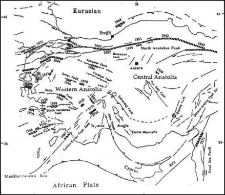
Figure 1. Tectonics of Western and Central Anatolia
Although
the Burdur-Dinar (Apameia) region to about 100 km to the Southwest of the
earthquake site has been repeatedly affected by large historical
earthquakes, the site of the Sultandagi earthquake has been relatively
free of the historical earthquakes. This may be the result of the very low
strain rates. Records of this century indicate in October 3, 1914 (M=7,
Io=IX) Burdur earthquake (37.50N, 32.50E), where about 4000 people died
and about 17000 houses destroyed, about 100 houses were destroyed in the
villages between Bolvadin and Cay. The earthquake is associated with a 23
km fault rupture along the southeast coast of the Burdur Lake. Another
earthquake of magnitude Ms=6 (I=VIII) occurred on August 7, 1925 at
Afyon-Dinar causing damage in the region lying between Hamidiye and
Denizli. On May 12, 1971 an earthquake (Ms=6.2, I=IX) occurred in town of
Burdur destroying 1487 houses and killing 57 persons. Another earthquake
of magnitude Ms=6.1 occurred on 1st October 1995 causing
extensive damage in Dinar town. The earthquake killed 90 people with 260
injured and caused extensive damage to 30% of buildings in Dinar. The
fault ruptures associated with those earthquakes are illustrated in Figure
1. The Sultandagi fault was recently activated by the 15.12.2000
(Mw=6.0) Bolvadin earthquake, which occurred in the southeastern part of
the fault zone. The earthquake caused 6 casualties with 82 injuries and
caused damage in
Bolvadin, Aksehir and Ilgin provinces. The epicenter of this earthquake is
shown on Figure 2.
The Sultandagi earthquake has taken place in the first-degree earthquake
hazard zone in the hazard map associated with the 1998 Turkish earthquake
resistant design regulations.
The affected cities Cay, Yakasinek,
Sultandagi are located on alluvial fans to the north of Sultandagi
mountains. The soil conditions represent gradation from stiff soil site to
alluvial deposits from south to north as morphology changes from mountain
slopes to fan deposits. The Eber village is located essantially on
holocene marshlike deposits.
The main shock and the distribution of aftershocks recorded at KOERI are given Figure 2. The epicenter and magnitude of the main shock, those of the following 3 major aftershocks and the rapid moment tensor solution of the main event as given by USGS are illustrated in Figure 3. The magnitude 6.0 event is considered as another main shock.
The
physical parameters of the earthquake are somewhat similar to the October
1, 1995 Dinar earthquake (Erdik et.al, 1998, Soil Dynamics and Earthquake
Engineering 17, 99.557-578). Both earthquakes have normal fault
mechanisms:
Dinar
Earthquake: Mw=6.0 (USGS)
Seismic Moment: Mo=1.3*10^18 Nm
Dinar
earthquake caused a fresh fault scarp with about 30cm vertical and 5cm
right lateral fault offset.
The maximum PGA recorded in Dinar Earthquake 0.33g at Dinar City. A total
of 90 people killed and about 1000 buildings became useless in the Dinar
City of population 35,000.
The
Seismic Moment of the Sultandagi Earthquake is about two times that of the
Dinar Earthquake.
Sultandagi
Earthquake Mw=6.3 (USGS)
Seismic
Moment: Mo=2.9*10^18 Nm
Preliminary reports indicate about 30km scarp.
Peak ground accelerations caused by the Mw=6.3 and by the Mw=6.0 earthquakes are given in Figure 4 respectively.
A preliminary list of important events of the earthquake episode is provided in Table 1.
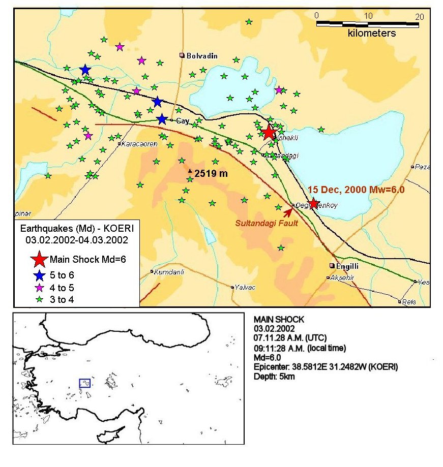
Figure 2. The main shock and the aftershock distribution
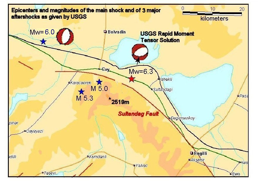
Figure 3. The main shock and the major aftershocks as given by USGS.
Table 1. List of the major events
| Date | Time(UTM) | USGS | KOERI | Depth (USGS) | Md | Mw |
| 03.02.2002 | 07:11 | 38:521N 31.156E | 38.5812N 31.2482E | 10 | 6.0 | 6.3 |
| 03.02.2002 | 09:26 | 38.646N 30.819E | 38.6855N 30.8350E | 10 | 5.3 | 6.0 |
| 03.02.2002 | 11:39 | 38.53N 30.96E | 38.6317N 30.9973E | 10 | 5.1 | - |
| 03.02.2002 | 11:54 | 38.56N 31.03E | 38.6013N 31.0077E | 10 | 5.0 | - |

Figure 4. Peak ground accelerations recorded from the Mw=6.3 event (indicated in red) and from the Mw=6.0 event (indicated in blue).
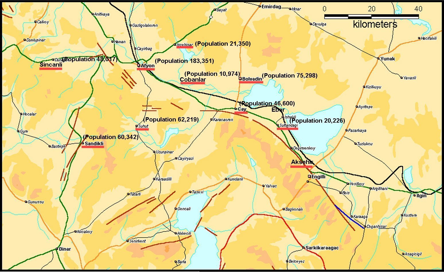
The
earthquake caused damage in Aksehir, Bolvadin, Cay, Cobanlar, Derecine,
Eber, Pazaragac, Sultandagi, Yakasinek and Yeniciftlik districts of Afyon.
The distribution of causalities and damaged buildings are given in the
tables below.
Table
2. Damage Distribution
|
Location |
Heavy damage and Collapse |
Medium Damage |
Low Damage |
|||
| Residential | Commercial | Residential | Commercial | Residential | Commercial | |
| Bolvadin | 471 | 35 | 436 | 254 | 3,134 | 408 |
| Cay | 1,226 | 245 | 136 | 14 | 1,660 | 29 |
| Cobanlar | 446 | 5 | 375 | 35 | 981 | 37 |
| Iscehisar | 45 | 1 | 3 | - | 55 | 1 |
| Merkez | 1,116 | 37 | 143 | 7 | 1,597 | 26 |
| Sincanli | 35 | 1 | 2 | 1 | 52 | 2 |
| Suhut | - | - | - | - | 99 | - |
| Sultandagi | 712 | 15 | 302 | 22 | 1,427 | 48 |
| Total | 4,051 | 339 | 1,397 | 333 | 9,005 | 551 |
Table
3. Casualty Distribution
|
Location |
Dead |
Injured |
|
Aksehir |
1 |
7 |
|
Bolvadin |
2 |
200 |
|
Cay |
23 |
67 |
|
Cobanlar |
- |
21 |
|
Merkez |
2 |
- |
|
Sincanli |
1 |
- |
|
Sultandagi |
13 |
30 |
|
Total |
42 |
325 |
The
damaged towns are illustrated in Figure
5.

Figure
5. Damage distribution
The intensity map compiled with the help of the above mentioned damages and field observations is given in Figure 6.

Figure 6. Intensity Distribution
VII. Performance Of Building Structures
Heavy
damage and total collapse were particularly concentrated in a narrow
region in Cay. Older single story buildings in the region are commonly
himis structures (buildings composed of timber frames and braces with
adobe infills), whereas newer ones are unreinforced masonry and reinforced
concrete structures typically with two or three stories.
1. Performance of Himis Structures
Most
of the injuries and casualties in the region are associated with the total
collapse of himis buildings. Himis buildings had been widely preferred in
rural areas three or four decades ago and were traditionally built
by their residents without engineering considerations. Thick perimeter
walls and heavy roofs are common features of himis buildings providing
heat isolation of the structure.The observed performance level of himis
buildings indicated heavy damage and total collapse due to the poor
strength and brittle behavior of the walls and considerable mass of the
buildings. Observations suggest that due the lack of rigid diaphragm
action, most of the walls responded individually during the seismic
attack. Moreover observation on collapsed buildings indicated that as a
consequence of weak connections between the perimeter and orthogonal
partitioning walls, separation occurred and most of the thick perimeter
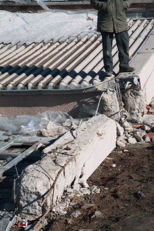
walls collapsed in the out of plane direction. Figure
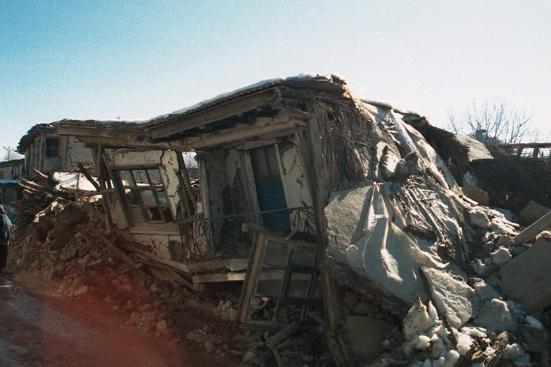
7 shows a collapsed himis buildings in Eber.
Unreinforced masonry has always been preferred to reinforced masonry in Turkey despite its handicaps in seismic behavior. However Turkish seismic codes have eliminated the disadvantages by limiting the number of stories (e.g. maximum 2 stories for Seismic Zone 1, and 3 stories for Seismic Zone 2) with conservative detailing and force reduction factors. Eventually most of the buildings in the region satisfy the story limitation rules for seismic Zone 1, however newer masonry buildings with 3 or 4 stories have also been inspected.
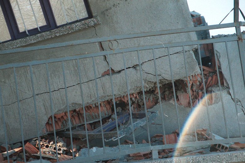
Observed heavy damage and collapse of unreinforced masonry buildings in the region are associated with hollow clay tiles used instead of solid brick units. Hollow clay tiles are widely used as infill panels in reinforced concrete buildings and are not allowed for masonry structures as load bearing members. First story collapse (Figure 8) is the common type of mechanism for the structures built with hollow clay tiles as a consequence of their very limited ductility capacities and poor strengths. Wide shear cracks between voids in the walls and evidence of crushing (Figure 9) has commonly been observed in heavily damaged hollow clay tiled buildings. However most of the buildings with less than 3 stories have survived the earthquake with minor damage even though they were built with hollow clay tiles.
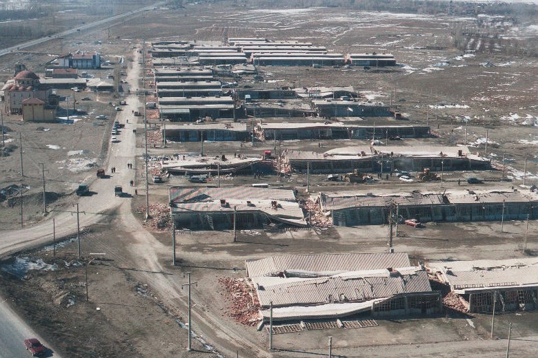
The majority of heavy damage and collapse of reinforced concrete buildings
have been limited to a narrow region in Cay. Estimated peak ground
acceleration (PGA) in Cay, which is approximately 10km away from the
epicenter, is around 0.20-0.25g. Most of the buildings of the Cay
Commercial Blocks collapsed while the remaining ones survived the
earthquake with very heavy damage (Figure 10).
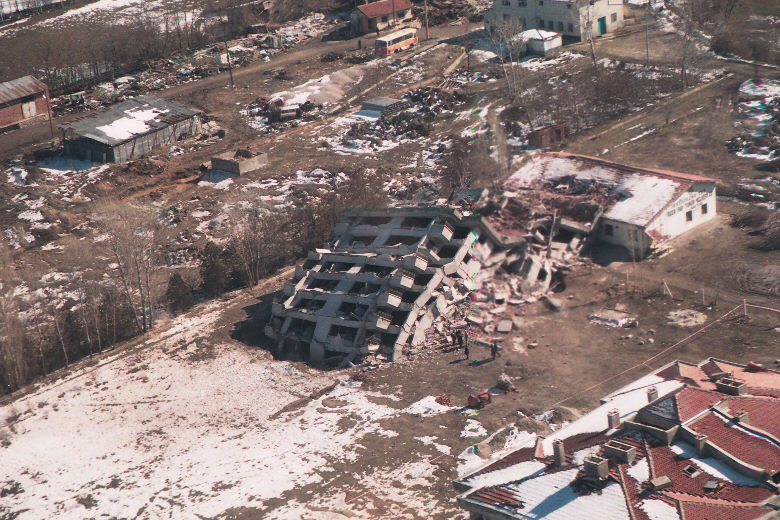
One of the triple 8 story apartment buildings in Cay that is very close to
the Cay Commercial Blocks, totally collapsed (Figure
11) and the mosque of the Cay Commercial Blocks suffered considerable
damage (Figure 10-Upper left). Fortunately collapse of these structures
did no cause any fatalities since it was an off-day for the Cay Commercial
Blocks’ workers and the 8-story buildings were unoccupied at the time of
the earthquake.
Buildings in Cay out of this region, Eber and Sultandagi performed well due to either the adequate design considerations taken into account or the level of ground motion that is not strong enough to test these structures.
a.
Cay Commercial Building Blocks
At
least 30% of the blocks were totally collapsed and the remaining blocks
suffered very heavy damage. The blocks were designed and completed in
90’s where each block was composed of 4 spans in the transverse
direction and 5 spans in the longitudinal direction. Observations suggest
that plain round bars (fy=220 MPa, 40 ksi) and deformed
bars (fy=420 MPa, 60 ksi) have been used as
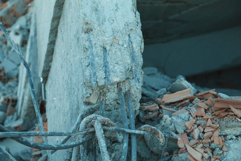
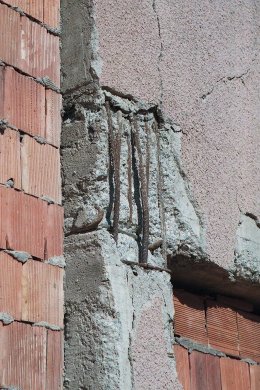
reinforcement. Bond failure of the column bars has been observed to be the
major cause of the collapse where the column bars were not bent as 900
hooks in the beam-column joints and splices at column bases inadequately
lapped. This resulted in the slip of the column bars from the joints and
foundations before a sound plastic mechanism commences in the potential
plastic hinge zones. Most of the collapsed blocks support this idea, that
is, some of the columns either collapsed in the opposite direction of the
collapsed slab or survived the earthquake even though the slab it has been
supporting collapsed (Figure 12, Figure
13). Blocks that could survive the seismic attack also show the
evidence of wide flexural cracks concentrated at the beam-column joint
faces and splitting cracks in the beam-column joints, indicating some
level of bar slip.
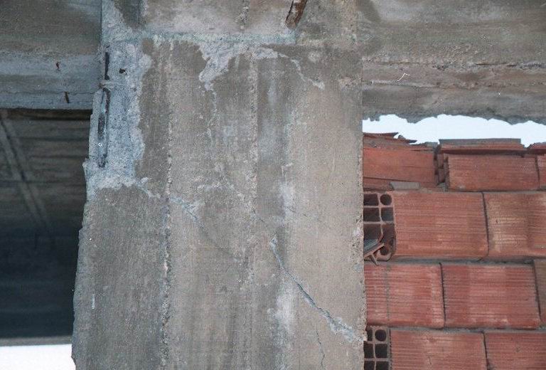
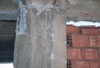
There are instances of column core concrete crushing as a consequence of inadequate transverse reinforcement failure. Transverse reinforcement spacing of 200 mm is common in most of the columns and most of the transverse reinforcement with 900 hooks opened (Figure 14) during the earthquake due to their poor anchorage features particularly after cover concrete spalling. Exterior beam-column joint failures have also been observed in some blocks. Details of the joints suggest that outer column bars buckled and joint cores crushed to some extent due to the lack of joint transverse reinforcement (Figure 15).
b.
The Mosque of Cay Commercial Building Blocks
This soft story building survived the seismic attack with considerable damage. The structure is reinforced with plain round bars (fy=220 MPa, 40 ksi). Full depth single flexural cracks of 3-4mm wide at beams that are concentrated at column faces suggest some level of beam bar slip (Figure 16). Observed damage indicate that the building responded dominantly in the oblique direction causing biaxial bending at columns. Most of the bars buckled and cover concrete spalled at column corners. None of the columns exhibited shear-flexure cracks distributed over a constant length however one of the columns adjacent to infill walls in the first story failed in shear (Figure 17). It was observed that corner beam-column joints exhibited beam bar slip, longitudinal column bar buckling and some level of diagonal tension cracking (Figure 18).
It was not very easy to observe the behavior of member at the upper stories from outside screening however outer face of the building does not indicate any evidence of significant outer column damage.
c.
Triple 8-Story Apartment Buildings
One of the buildings of three identical apartments totally collapsed and the other lost its first two stories. Observations suggest that loss of column bar anchorage at the foundation level and probably at the story levels (Figure 19) caused the collapse of the former building. Columns of the collapsed building showed no evidence of distributed flexural or shear cracks suggesting the possibility that column bars slipped before the attainment of flexural capacity. First two stories of the latter building collapsed due to inadequate transverse reinforcement details. There are many instance of crushed concrete due to excessive transverse expansion of the core concrete and shear cracks in the weak direction of the columns.

Figure 7. Collapsed himis building in Eber

Figure 8. Collapsed masonry building built with hollow clay tiles
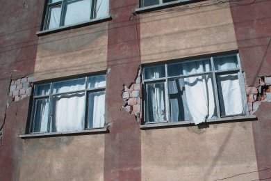
Figure 9. Heavily damaged 4 story masonry building in Cay.

Figure 10. Cay commercial blocks and its mosque

Figure 11. Collapsed and damaged 8-story apartment buildings

Figure 12. Collapsed column and slab in opposite directions

Figure 13. Collapsed slab due to bond failure of the column bars
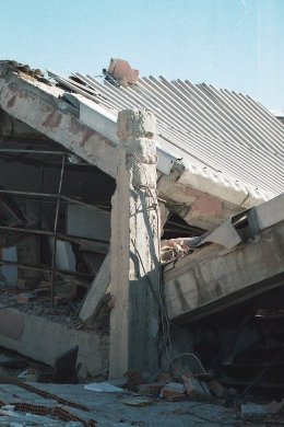
Figure 14. Spacing of transverse reinforcement visible in a column
Figure
15. Exterior beam-column joint damage
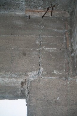
Figure 16. Full depth beam flexural crack
Figure
17. Observed column shear failure
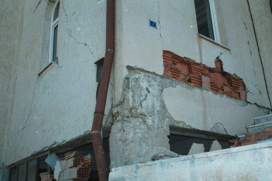
Figure 18. Damage at a beam-column joint
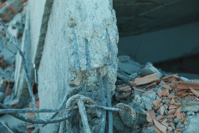
Figure 19. Bond failure at column base
To download the pdf version of this document click here.