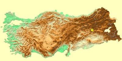
38.99N 40.46E(USGS)
Mw=6.4 (USGS)
MAY 1, 2003 BİNGÖL (TURKEY) EARTHQUAKEPreliminary Report (Updated on May 13, 2003) |
| DATE -TIME: | 2003 05 01 00:24:04 UTC | |
| LOCATION: | 39.0130N
40.4688E (KOERI) 38.99N 40.46E(USGS) |
|
| DEPTH: | 10.0 kilometers | |
| MAGNITUDE: | Ms=6.4 (KOERI) Mw=6.4 (USGS) |
|
After the earthquake,
teams from both the Seismology Laboratory and the Earthquake Engineering
Department of KOERI have been in the field. While the preliminary report
prepared by the Seismology Department reveals interesting findings about
faulting and mechanism, the work of the Earthquake Engineering team
concentrates mostly on strong ground motion instrumentation and
damage. |
|
TABLE OF CONTENTSII. Aftershock Activity and Earthquake Mechanism III. Strong Ground Motion IV. Historical and Instrumental Seismicity V. Damage VI. Structural Performance in 1st May 2003, Bingöl Earthquake VII. Pictures
|
|
I. TECTONICS OF THE REGION |
|
|
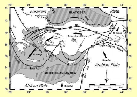
The tectonics of the region are controlled by the collision of the Arabian and Eurasian Plates. The northward motion of the Arabian plate relative to Eurasia causes lateral escape of the Anatolian block to the west (Ketin,1948, McKenzie,1972, Sengor,1979) and the Northeast Anatolian block to the east. The Anatolian block is bounded to the north and to the south-east by the North Anatolian and the East Anatolian faults, respectively. The
North Anatolian Fault (NAF) is the most eminent tectonic feature of the
region and one of the best known strike slip faults in the world. It is an
about 1500 km long, seismically active right lateral strike-slip fault
system extending from the Karlıova triple junction in eastern Turkey to
mainland Greece. Estimations on the age of the North Anatolian Fault range
from late Miocene to early Pliocene (e.g. Sengor, 1985, Barka, 1992). The
total relative displacement along the fault varies from 40 km in the east,
near Erzincan, to 15 km in the west, near the Marmara Sea (Barka and
Gulen, 1987). |
Major tectonic entities of the region |
|
The East Anatolian Fault Zone is a 550 km-long, approximately northeast-trending, left lateral strike-slip fault zone . The fault zone takes up the relative motion between the Anatolian and the Eurasian plates and, between the Arabian and African plates. The East Anatolian Fault Zone extends from Karlıova triple junction in the northeast to the Maraş triple junction in the southwest were it intersects the Dead Sea Fault. The age of the East Anatolian Fault is also highly debated. For instance Şengör et al. (1985), Dewey et al. (1986), Arpat and Şaroğlu (1972) place its formation in the Late Miocene-Early Pliocene. Zone is Pliocene (Barka, 1992). Şaroğlu et al. (1992) argue that the fault is Late Pliocene. Westaway and Arger (1998) suggested that the East Anatolian Fault Zone became active around 3 Ma. Suggestions for the total left lateral displacement along the fault vary between 3.5-13 km and 15-27 km (e.g. Arpat and Şaroğlu, 1972, 1975, Şaroğlu et al., 1992). Only a few major earthquakes occurred on the East Anatolian Fault during the 20th century. These are the December 4, 1905 (M=6.8) Malatya, September 28, 1908 (M=6.7), May 22, 1971 (M=6.8) Bingöl and May 5, 1986 (M=6.0) Sürgü earthquakes. Among those,the location of May 22, 1971 Bingöl earthquake is very close to the present earthquake which is also associated with the East Anatolian Fault system.
|
|
II. AFTERSHOCK ACTIVITY AND EARTHQUAKE MECHANISM |
|
|
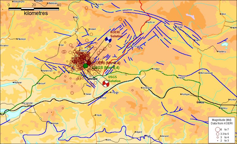
The aftershock activity with magnitude > 2 and the earthquake mechanisms as given by KOERI and USGS are illustrated in the following figure. |
|
|
|
|
|
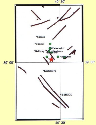
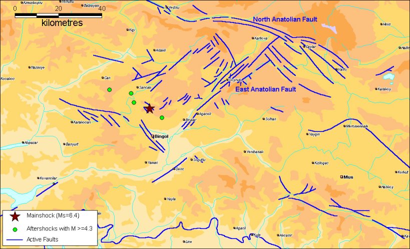
Field observations conducted by the Seismology Laboratory team are summarized on the figure in the right (Preliminary Report prepared by the Seism. Lab.). Here the green circles show sites where fault traces, fault breaks in the surface, settlements, landslides and toppled rocks were observed. Brown lines show active faults in the region as compiled by Saroğlu et al. (1992). The epicentral location of the 2003 Bingol earthquake agrees well with the NW-SE trending fault shown in the figure. The report associates the present earthquake with the N-NE trending fault passing from Kurtulus-ElmaCayiri-Hanocayiri and continuing towards Balikcay-Cimenli. Although the aftershock distribution with M>2 exhibits a somewhat diffuse pattern, the alignment of the aftershocks with magnitude >= 4.3 is also in agreement with the suggestion of NW-SE trending fault break (Preliminary Report prepared by the Seism. Lab.). The epicentral locations of the aftershocks with M >= 4.3 are shown in the figure below.
|
|
|
|
|
III. STRONG GROUND
MOTION
|
|
|
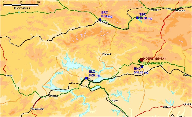
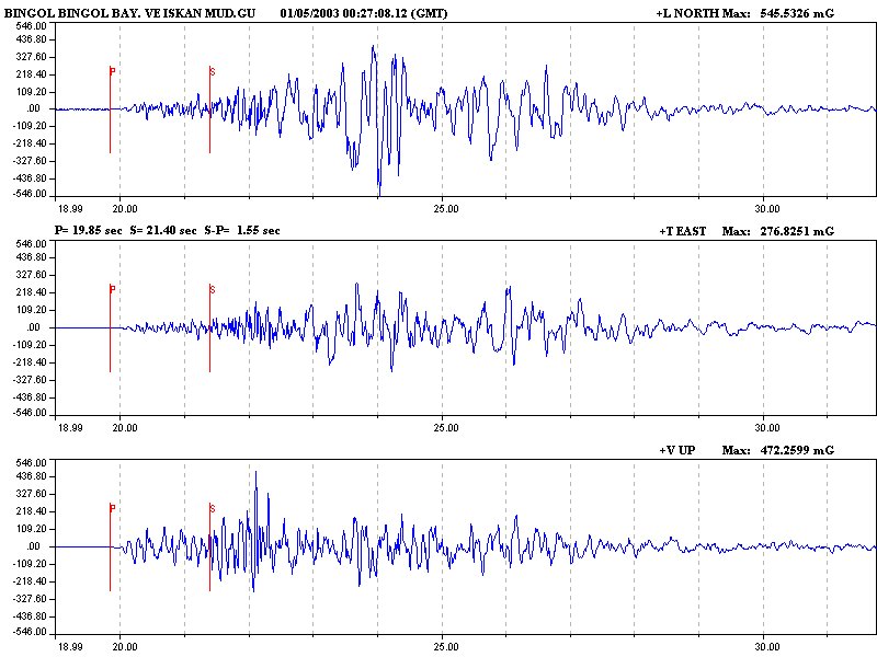
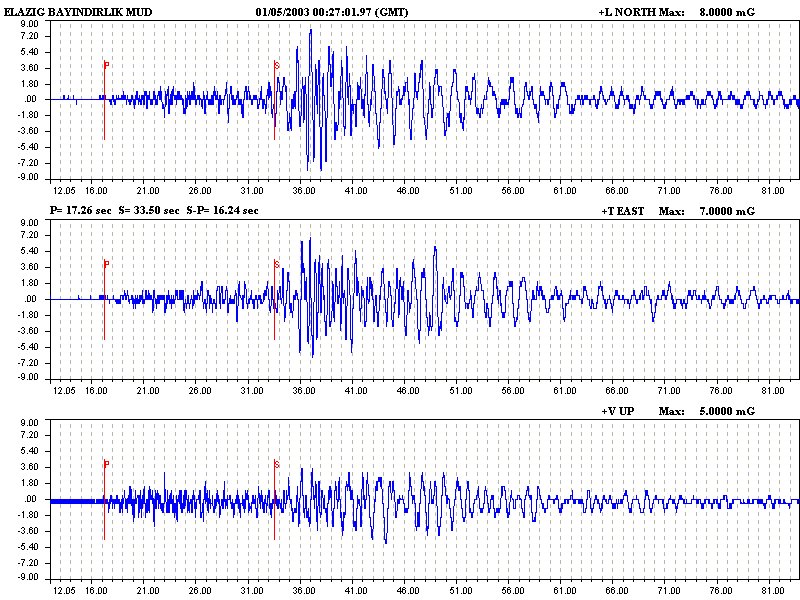
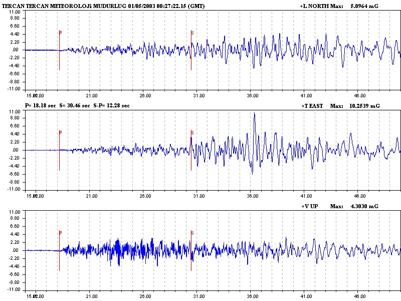
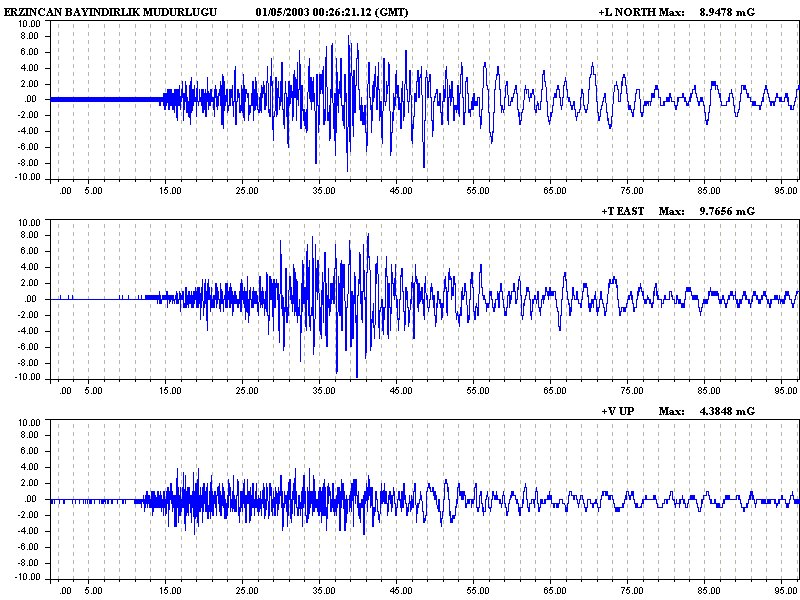
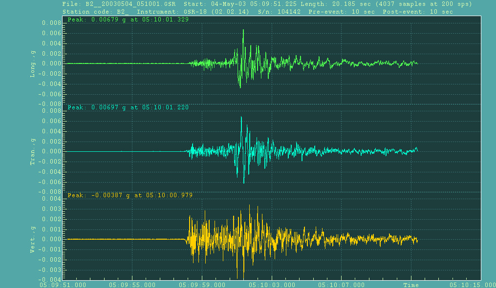
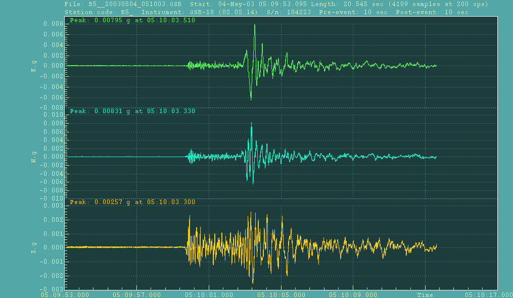
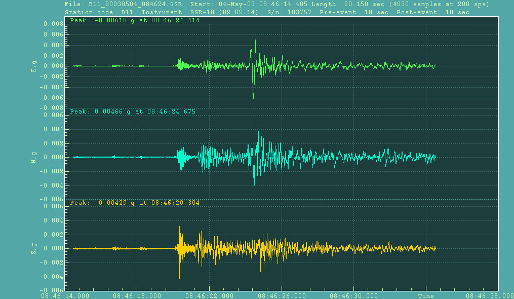
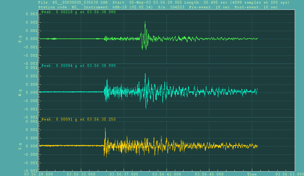
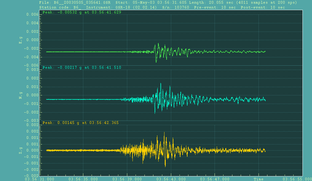
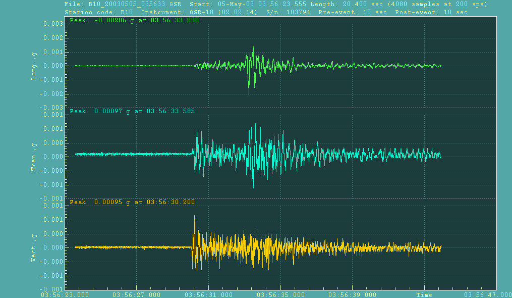
The
earthquake was recorded by four strong motion recording stations operated
by the Earthquake Research Department of General Dir. of Disaster Affairs
( http://angora.deprem.gov.tr/sond.htm).
The horizontal peak ground accelerations are presented in the
following figure. To view the accelerograms, please click on the
hyperlinks in the table below. |
|
|
|
|
|
||||||||||||||||||||||||||||||||||||||||||||||||||||||||||||||||||||||||||||||||||||||||||||||||||||||||||||||||||||||||||||||||||||||||||||||||||||||||||||||||||||||||||||||||||||||||||||||||||||||||||||||||||||||||||||||||||||||||||||||||||||||||||||||||||||||||||||||||||||||||||||||||||||||||||||||||||||||||||||||||||||||||||||||||||||||||||||||||||||||||||||||||||||||||||||||||||||||||||||||||||||
|
|
||||||||||||||||||||||||||||||||||||||||||||||||||||||||||||||||||||||||||||||||||||||||||||||||||||||||||||||||||||||||||||||||||||||||||||||||||||||||||||||||||||||||||||||||||||||||||||||||||||||||||||||||||||||||||||||||||||||||||||||||||||||||||||||||||||||||||||||||||||||||||||||||||||||||||||||||||||||||||||||||||||||||||||||||||||||||||||||||||||||||||||||||||||||||||||||||||||||||||||||||||||
|
||||||||||||||||||||||||||||||||||||||||||||||||||||||||||||||||||||||||||||||||||||||||||||||||||||||||||||||||||||||||||||||||||||||||||||||||||||||||||||||||||||||||||||||||||||||||||||||||||||||||||||||||||||||||||||||||||||||||||||||||||||||||||||||||||||||||||||||||||||||||||||||||||||||||||||||||||||||||||||||||||||||||||||||||||||||||||||||||||||||||||||||||||||||||||||||||||||||||||||||||||||
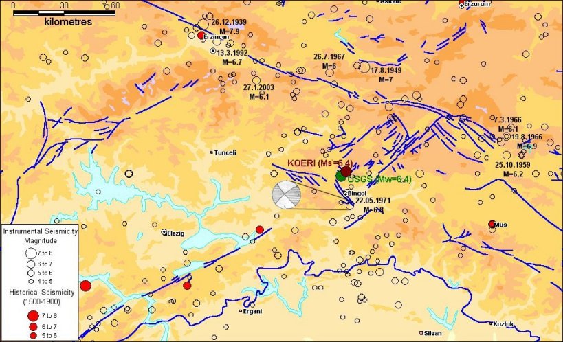
IV. HISTORICAL AND INSTRUMENTAL SEISMICITY
|
||||||||||||||||||||||||||||||||||||||||||||||||||||||||||||||||||||||||||||||||||||||||||||||||||||||||||||||||||||||||||||||||||||||||||||||||||||||||||||||||||||||||||||||||||||||||||||||||||||||||||||||||||||||||||||||||||||||||||||||||||||||||||||||||||||||||||||||||||||||||||||||||||||||||||||||||||||||||||||||||||||||||||||||||||||||||||||||||||||||||||||||||||||||||||||||||||||||||||||||||||||
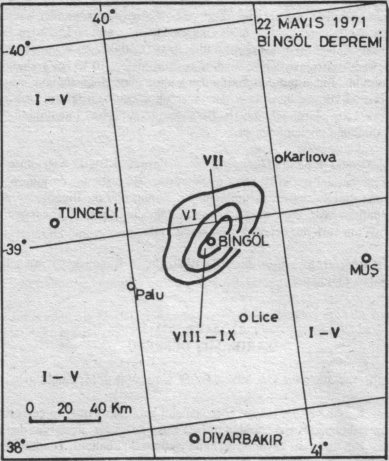
May 22, 1971 M=6.8 Bingöl Earthquake |
||||||||||||||||||||||||||||||||||||||||||||||||||||||||||||||||||||||||||||||||||||||||||||||||||||||||||||||||||||||||||||||||||||||||||||||||||||||||||||||||||||||||||||||||||||||||||||||||||||||||||||||||||||||||||||||||||||||||||||||||||||||||||||||||||||||||||||||||||||||||||||||||||||||||||||||||||||||||||||||||||||||||||||||||||||||||||||||||||||||||||||||||||||||||||||||||||||||||||||||||||||
|
|
The
northeastern segment of the East Anatolian Fault between the Karlıova
triple junction and Bingöl is about 60 km long and is composed of many
closely spaced parallel strike-slip faults strands. The 1971 Bingöl
earthquake produced surface breaks mostly along the southwestern half of
this segment. The relocated epicenter for the 1971 earthquake is at the
southwestern end of the surface breaks. Although the exact locations are
not known, two historical earthquakes of similar size, namely the 1789 and
the 1875 events, are reported to have occurred in the vicinity of this
segment (Barka and Kadinsky-Cade, 1988).
The
1971 event, preceded by a few foreshocks, caused considerable damage at
Bingöl and its vicinity. Death of 881 and injury of 1157 people heve been
reported. 3965 buldings were collapsed, 6950 buildings were heavily
damaged, 9847 were moderately and 350 buildings were slightly damaged. The
earthquake produced a belt of surface breaks, approximately 38 km long,
from SE of Bingöl to Cobantasi. Both field observations on surface breaks
and earthquake mechanism solutions (Dewey, 1976; Taymaz et al.,1991)
reveal a left-lateral strike slip geometry (Eyidoğan et al., 1991)
|
|||||||||||||||||||||||||||||||||||||||||||||||||||||||||||||||||||||||||||||||||||||||||||||||||||||||||||||||||||||||||||||||||||||||||||||||||||||||||||||||||||||||||||||||||||||||||||||||||||||||||||||||||||||||||||||||||||||||||||||||||||||||||||||||||||||||||||||||||||||||||||||||||||||||||||||||||||||||||||||||||||||||||||||||||||||||||||||||||||||||||||||||||||||||||||||||||||||||||||||||||||
V. DAMAGEThe municipality of Bingöl announced that in the city 308 housing units were collapsed, 2566 housing units were heavily damaged and 2546 housing units were lightly damaged. Death of 168, and injuries of 520 people have been reported by the Government sources. Currently
our team is on the field, and information about damage will be updated
regularly. |
||||||||||||||||||||||||||||||||||||||||||||||||||||||||||||||||||||||||||||||||||||||||||||||||||||||||||||||||||||||||||||||||||||||||||||||||||||||||||||||||||||||||||||||||||||||||||||||||||||||||||||||||||||||||||||||||||||||||||||||||||||||||||||||||||||||||||||||||||||||||||||||||||||||||||||||||||||||||||||||||||||||||||||||||||||||||||||||||||||||||||||||||||||||||||||||||||||||||||||||||||||
VI.
Structural
Performance in 1st May 2003, Bingöl Earthquake
|
||||||||||||||||||||||||||||||||||||||||||||||||||||||||||||||||||||||||||||||||||||||||||||||||||||||||||||||||||||||||||||||||||||||||||||||||||||||||||||||||||||||||||||||||||||||||||||||||||||||||||||||||||||||||||||||||||||||||||||||||||||||||||||||||||||||||||||||||||||||||||||||||||||||||||||||||||||||||||||||||||||||||||||||||||||||||||||||||||||||||||||||||||||||||||||||||||||||||||||||||||||
|
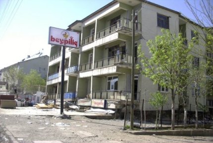
The
structural type of the city is generally composed of reinforced concrete
buildings up to five or six stories, himis (buildings composed of timber
frames and braces with adobe infills), and un-reinforced masonry
structures. Both himis and masonry buildings are concentrated in the old
city part (South West part) and the reinforced concrete buildings are
concentrated in the north part of the city where the housing settlement
has moved after 1971 earthquake. |
||||||||||||||||||||||||||||||||||||||||||||||||||||||||||||||||||||||||||||||||||||||||||||||||||||||||||||||||||||||||||||||||||||||||||||||||||||||||||||||||||||||||||||||||||||||||||||||||||||||||||||||||||||||||||||||||||||||||||||||||||||||||||||||||||||||||||||||||||||||||||||||||||||||||||||||||||||||||||||||||||||||||||||||||||||||||||||||||||||||||||||||||||||||||||||||||||||||||||||||||||||
1.
Performance
of Himis Buildings
|
||||||||||||||||||||||||||||||||||||||||||||||||||||||||||||||||||||||||||||||||||||||||||||||||||||||||||||||||||||||||||||||||||||||||||||||||||||||||||||||||||||||||||||||||||||||||||||||||||||||||||||||||||||||||||||||||||||||||||||||||||||||||||||||||||||||||||||||||||||||||||||||||||||||||||||||||||||||||||||||||||||||||||||||||||||||||||||||||||||||||||||||||||||||||||||||||||||||||||||||||||||
|
Most of the himis
buildings are located in Mirzan, Yeni and Yeşilyurt districts. Himis is
widely used structural type of building in the Eastern part of Turkey that
is built by their residents without engineering considerations. A typical himis
building is composed of the thick perimeter walls and heavy roofs to
provide heat isolation of the structure. |
||||||||||||||||||||||||||||||||||||||||||||||||||||||||||||||||||||||||||||||||||||||||||||||||||||||||||||||||||||||||||||||||||||||||||||||||||||||||||||||||||||||||||||||||||||||||||||||||||||||||||||||||||||||||||||||||||||||||||||||||||||||||||||||||||||||||||||||||||||||||||||||||||||||||||||||||||||||||||||||||||||||||||||||||||||||||||||||||||||||||||||||||||||||||||||||||||||||||||||||||||||
2.
Performance
of Unreinforced Masonry Buildings
|
||||||||||||||||||||||||||||||||||||||||||||||||||||||||||||||||||||||||||||||||||||||||||||||||||||||||||||||||||||||||||||||||||||||||||||||||||||||||||||||||||||||||||||||||||||||||||||||||||||||||||||||||||||||||||||||||||||||||||||||||||||||||||||||||||||||||||||||||||||||||||||||||||||||||||||||||||||||||||||||||||||||||||||||||||||||||||||||||||||||||||||||||||||||||||||||||||||||||||||||||||||
|
In
addition to the himis type of structures, there were also some
un-reinforced masonry buildings in different regions of the city. Although
their seismic performance is not good enough during earthquakes,
unreinforced masonry buildings are preferred to reinforced masonry
buildings in Turkey. But in the Turkish Seismic Code this issue is
eliminated to some extent by limiting the story number according to the
Seismic Zones. (e.g. max. 2 stories in seismic Zone 1). In addition to
this some conservative connection detailing and force reduction factors
are given to overcome this handicap. |
||||||||||||||||||||||||||||||||||||||||||||||||||||||||||||||||||||||||||||||||||||||||||||||||||||||||||||||||||||||||||||||||||||||||||||||||||||||||||||||||||||||||||||||||||||||||||||||||||||||||||||||||||||||||||||||||||||||||||||||||||||||||||||||||||||||||||||||||||||||||||||||||||||||||||||||||||||||||||||||||||||||||||||||||||||||||||||||||||||||||||||||||||||||||||||||||||||||||||||||||||||
3.
Performance
of Reinforced Concrete Buildings
|
||||||||||||||||||||||||||||||||||||||||||||||||||||||||||||||||||||||||||||||||||||||||||||||||||||||||||||||||||||||||||||||||||||||||||||||||||||||||||||||||||||||||||||||||||||||||||||||||||||||||||||||||||||||||||||||||||||||||||||||||||||||||||||||||||||||||||||||||||||||||||||||||||||||||||||||||||||||||||||||||||||||||||||||||||||||||||||||||||||||||||||||||||||||||||||||||||||||||||||||||||||
|
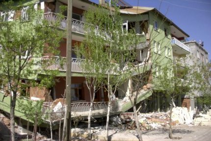
Like
in the most of the Turkey, reinforced concrete structures are the majorty
of the total structural stock in the city. The reinforced concrete
buildings are mostly composed of columns and beams and a few of them have
shear walls. Most of the reinforced concrete buildings in Inönü, Saray,
Yeni and Yenişehir districts were heavily damage and collapsed. And in
the other districts like Bahçelievler, Düzağaç and Yeşilyurt the
reinforced concrete buildings were slightly damaged.
|
||||||||||||||||||||||||||||||||||||||||||||||||||||||||||||||||||||||||||||||||||||||||||||||||||||||||||||||||||||||||||||||||||||||||||||||||||||||||||||||||||||||||||||||||||||||||||||||||||||||||||||||||||||||||||||||||||||||||||||||||||||||||||||||||||||||||||||||||||||||||||||||||||||||||||||||||||||||||||||||||||||||||||||||||||||||||||||||||||||||||||||||||||||||||||||||||||||||||||||||||||||
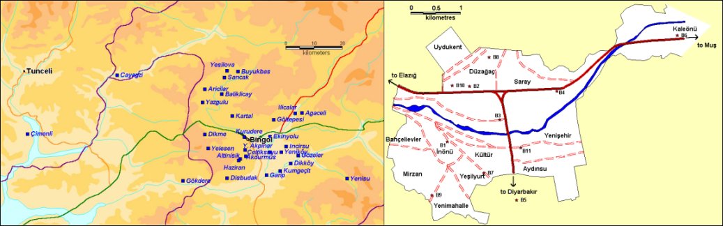
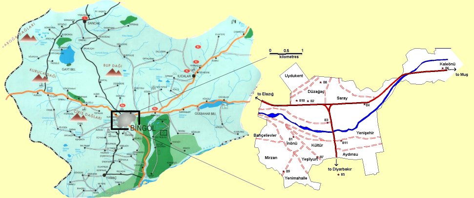
Damaged villages in the vicinity of Bingöl Districts in Bingöl City center |
||||||||||||||||||||||||||||||||||||||||||||||||||||||||||||||||||||||||||||||||||||||||||||||||||||||||||||||||||||||||||||||||||||||||||||||||||||||||||||||||||||||||||||||||||||||||||||||||||||||||||||||||||||||||||||||||||||||||||||||||||||||||||||||||||||||||||||||||||||||||||||||||||||||||||||||||||||||||||||||||||||||||||||||||||||||||||||||||||||||||||||||||||||||||||||||||||||||||||||||||||||
Damage Assessment Results
|
||||||||||||||||||||||||||||||||||||||||||||||||||||||||||||||||||||||||||||||||||||||||||||||||||||||||||||||||||||||||||||||||||||||||||||||||||||||||||||||||||||||||||||||||||||||||||||||||||||||||||||||||||||||||||||||||||||||||||||||||||||||||||||||||||||||||||||||||||||||||||||||||||||||||||||||||||||||||||||||||||||||||||||||||||||||||||||||||||||||||||||||||||||||||||||||||||||||||||||||||||||
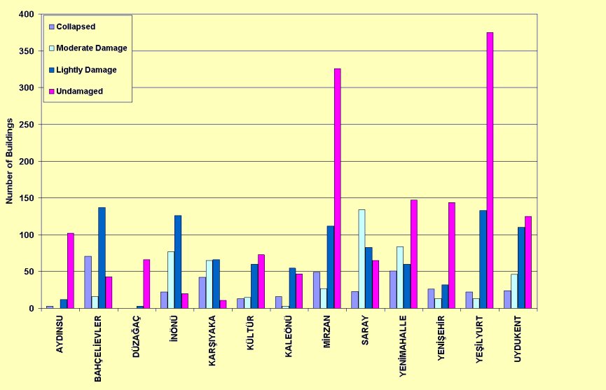
| Heavy damage and Collapse | Medium Damage | Low Damage | Undamaged | |||||||||
| Location | Buildings | Residential | Commercial | Buildings | Residential | Commercial | Buildings | Residential | Commercial | Buildings | Residential | Commercial |
| AYDINSU | 3 | 3 | - | - | - | - | 12 | 16 | - | 102 | 157 | - |
| BAHÇELİEVLER | 71 | 73 | 2 | 16 | 30 | 2 | 137 | 254 | 24 | 43 | 144 | 11 |
| DÜZAĞAÇ | - | - | - | - | - | - | 3 | 4 | - | 66 | 74 | - |
| İNÖNÜ | 22 | 95 | 19 | 77 | 274 | 15 | 126 | 212 | 47 | 20 | 19 | 48 |
| KARŞIYAKA | 42 | 162 | 3 | 65 | 779 | 7 | 66 | 349 | 2 | 11 | 28 | 1 |
| KÜLTÜR | 13 | 58 | 6 | 15 | 61 | 3 | 60 | 187 | 4 | 73 | 131 | 3 |
| KALEÖNÜ | 16 | 16 | 3 | 3 | 5 | - | 55 | 69 | 3 | 47 | 46 | 5 |
| MİRZAN | 49 | 55 | - | 27 | 33 | - | 112 | 138 | - | 326 | 512 | 1 |
| SARAY | 23 | 56 | 7 | 134 | 750 | 48 | 83 | 365 | 7 | 65 | 308 | 7 |
| YENİMAHALLE | 51 | 102 | 11 | 84 | 59 | 21 | 60 | 141 | 20 | 147 | 287 | 36 |
| YENİŞEHİR | 26 | 61 | 13 | 13 | 100 | 27 | 32 | 246 | 74 | 144 | 633 | 73 |
| YEŞİLYURT | 22 | 54 | 8 | 13 | 22 | 1 | 133 | 240 | 30 | 375 | 424 | 10 |
| UYDUKENT | 24 | 26 | - | 46 | 94 | 8 | 110 | 373 | 22 | 125 | 392 | 6 |
| TOTAL | 362 | 761 | 72 | 493 | 2207 | 132 | 989 | 2594 | 233 | 1544 | 3155 | 201 |
| Heavy damage and Collapse | Medium Damage | Low Damage | Undamaged | |||||||||
| Location | Buildings | Residential | Commercial | Buildings | Residential | Commercial | Buildings | Residential | Commercial | Buildings | Residential | Commercial |
| ILICALAR | 39 | 48 | - | 45 | 45 | - | 240 | 262 | 1 | 16 | 33 | - |
| SANCAK | 69 | 72 | - | 27 | 28 | - | 39 | 39 | - | 101 | 100 | 1 |
| AKDURMUS | 26 | 26 | - | - | - | - | 23 | 23 | - | 22 | 22 | - |
| ALTINIŞIK | 15 | 15 | - | - | - | - | 8 | 9 | - | 4 | 6 | - |
| AĞAÇELİ | 2 | 2 | - | - | - | - | 37 | 37 | 1 | 30 | 34 | - |
| ARICILAR | 9 | 9 | - | 8 | 11 | - | 38 | 48 | - | 17 | 24 | - |
| BALIKLIÇAY | 46 | 46 | - | 15 | 15 | - | 21 | 21 | - | 17 | 17 | - |
| ÇAYAĞZI | 7 | 7 | - | 1 | 1 | - | 36 | 36 | - | 13 | 13 | - |
| ÇİÇEKYAYLA | 27 | 30 | - | 1 | 1 | - | 7 | 8 | - | 1 | 1 | - |
| DİKKÖYÜ | 3 | 3 | - | - | - | - | 87 | 69 | - | 87 | 88 | - |
| DİKME | 34 | 34 | - | 9 | 9 | - | 5 | 5 | - | 10 | 10 | - |
| DIŞBUDAK | 1 | 1 | - | - | - | - | 21 | 21 | - | 2 | 2 | - |
| EKİNYOLU | 87 | 89 | 1 | 3 | 5 | - | 121 | 121 | 1 | 58 | 78 | 3 |
| GARİP | 20 | 20 | - | - | - | - | 57 | 57 | - | 73 | 72 | 1 |
| GÖZELER | 27 | 27 | - | - | - | - | 95 | 96 | - | 99 | 106 | - |
| GÖLTEPESİ | 103 | 108 | - | 46 | 47 | - | 19 | 19 | - | 3 | 3 | - |
| GÖKDERE | 26 | 26 | - | - | - | - | 33 | 33 | - | 44 | 44 | - |
| HAZİRAN | 50 | 50 | - | 1 | 1 | - | 7 | 7 | - | - | - | - |
| İNCESU | 76 | 77 | - | 2 | 2 | - | 28 | 27 | 1 | 34 | 33 | 1 |
| KARTAL | 11 | 11 | - | 7 | 7 | - | 18 | 18 | - | 35 | 35 | - |
| KUMGEÇİT | 3 | 3 | - | - | - | - | 23 | 23 | - | 17 | 17 | - |
| KURUDERE | 7 | 9 | - | 35 | 35 | - | 51 | 51 | - | 14 | 20 | - |
| SARIÇİÇEK | 103 | 103 | - | 3 | 3 | - | 8 | 8 | - | 36 | 64 | - |
| SUDÜĞÜNÜ | 79 | 90 | - | 81 | 87 | - | 32 | 32 | - | 11 | 8 | 2 |
| YELESEN | 68 | 68 | - | 6 | 6 | - | - | - | - | - | - | - |
| YENİKÖY | 21 | 23 | - | 1 | 2 | - | 59 | 70 | 1 | 23 | 22 | - |
| Y.AKPINAR | 25 | 26 | - | 1 | 1 | - | 7 | 7 | - | 18 | 27 | - |
| YAZGÜLÜ | 5 | 6 | - | 9 | 8 | 1 | 4 | 4 | - | 2 | 2 | - |
| TOTAL | 989 | 1029 | 1 | 301 | 314 | 1 | 1124 | 1151 | 5 | 787 | 881 | 8 |
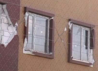
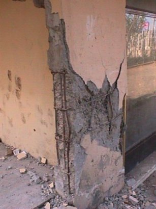
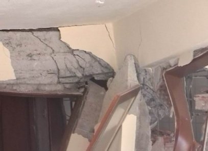
Observed shear
failure at shear wall due to insufficient transverse reinforcement
and poor concrete quality
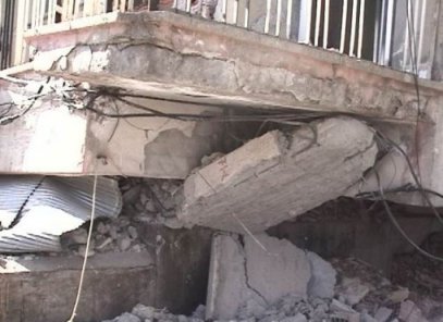
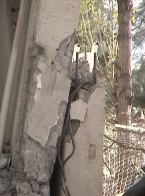
Shear failure at column base due to insufficient
amount of transverse reinforcement

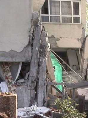
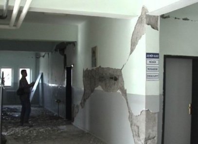
Collapsed first two stories
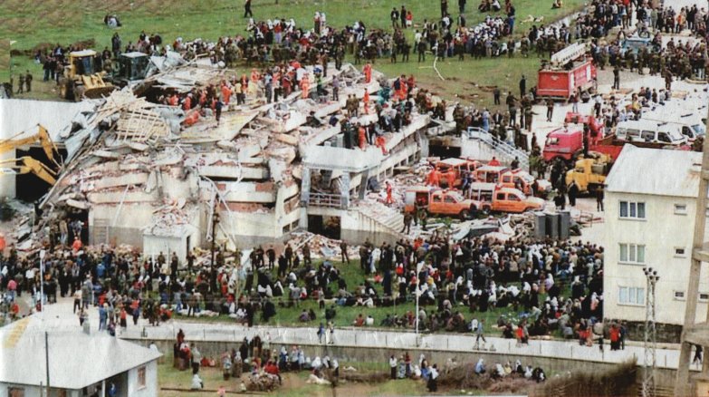
Çeltiksuyu
Boarding School (Akşam newspaper)
